Overview
Based on the analysis of commercial imagery, ground photography, and open reporting, we assess that gold mining and the associated usage and transportation of mercury have increased in riverine sections of Western Venezuela and Eastern Guyana.
The areas of San Martín de Turumbán, Cañamú, and Eterimbán are a focal point in the connection between gold mining and mercury transportation. If these trends continue, both Guyana and Venezuela will face growing insecurity and adverse socio-environmental repercussions.
Activity
We used a medium-sized data sample and case study of San Martín de Turumbán, Cañamú, and Eterimbán to illuminate broader imagery and land cover mining trends in riverine sections of Venezuela and Guyana such as mining expansion and mercury usage and transport. For example, imagery analysis shows expanding gold mining activity in the form of mining pits and tailing ponds at San Martín de Turumbán between 2016 and 2023. In addition to site and facility-level imagery analysis, we performed a land use and land cover (LULC) change analysis at 13 mining sites situated along the Venezuela-Guyana border between 2008 and 2022 to examine the extent of mining activity expansion. The LULC change analysis reveals an expansion of mining activity across all mining sites.
Background
The relationship between Guyana and Venezuela is particularly volatile due to the long-standing border dispute over the Essequibo Territory, an area spanning approximately 149,500 square kilometers that falls within Guyana’s borders but is claimed by Venezuela. SOS Orinoco, an advocacy group focused on highlighting human and environmental concerns in Venezuela, reports that activities linked to the designated Orinoco Mining Arc, an area nearly the size of Portugal dedicated to mineral extraction, have been spilling over into neighboring regions. Furthermore, the report highlights the presence of organized armed groups (OAGs) in Essequibo Territory's mining areas, originating from Venezuela's Bolívar state and using the Cuyuní River as a route. These OAGs exert control over illegal mining, smuggle mercury to boost gold mining efforts and escalate tension along the Venezuela-Guyana border. This endangers Guyana's sovereignty and bolsters Venezuela's territorial claims in the Essequibo Territory. OAGs also manage river routes connecting Venezuela's eastern region with Essequibo and run "informal" checkpoints for profit, relying on illegal cross-border trade, including mercury and gasoline, which further fuels territorial disputes in the region.
Despite Guyana ratifying the Minamata Convention in 2014, a global initiative to reduce the use of mercury in mining, it has become the main source of mercury for many South American countries. According to Raphael Trotman, the former Minister of the Environment in Guyana, once mercury enters the country, there are no restrictions on its trade or movement. The unrestricted flow of mercury throughout Guyana facilitates the transportation of this substance to neighboring countries. On the other hand, Venezuela signed the Minamata Convention in 2016, but it did not reach ratification. Therefore, alongside other countries, Venezuela has established itself as a mercury trafficking destination due to its proximity to Guyana.
Liquid mercury is used in gold mining to form an amalgam with gold, which is then heated and vaporized to acquire the gold. Small-scale miners often choose to use mercury due to its simplicity, cost-effectiveness, and ability to capture fine gold particles, despite the associated environmental and health risks. In 2019, a U.S. Senate hearing addressed the issue of illegal mining in Latin America, highlighting human rights concerns with a particular focus on the use of mercury and its various negative impacts. During the hearing, while discussing Bolivar State in Venezuela, Carrie Filipetti, Deputy Assistant Secretary of Western Hemisphere Affairs, stated that "a test performed in mining communities recently showed that over 90 percent of people working in the mines in Bolivar had unsafe concentrations of mercury in their urine."
Gold Mining Legality and Criminal Association
The legal status of mining activities in the Orinoco Mining Arc is a complex and controversial issue. The term "illegal" is often applied by organizations and groups critical of Venezuelan President Maduro's human rights and environmental record, autocratic behavior, and use of state assets to legitimize corruption and criminal elements engaged in gold mining, transport, export, and sales. President Maduro created the Orinoco Mining Arc in early 2016 through emergency economic powers despite the National Assembly rejecting the economic decree. Venezuela’s Supreme Court reinstated the decree allowing Maduro to bypass constitutionally mandated environmental and indigenous community impact assessments. While Maduro’s executive decree is the legal basis for mining within the Orinoco Mining Arc, international organizations and advocacy groups cite the disregard for Venezuela’s Constitution, human rights violations, and immense environmental degradation as the reasons for the illegality of mining.
In addition to the legal controversy surrounding mining activities, there is widespread criminal activity around gold mining operations, especially within the Orinoco Mining Arc and our case study area. The Center for Strategic and International Studies (CSIS) noted the Mining Arc’s high presence of criminal activity, "where armed non-state actors and local gangs compete for control of key mining operations." Additionally, the area of our study is noted by locals as having a substantial criminal presence with camps along the road route to San Martín governed by the Colombian National Liberation Army (ELN).
Area of Interest
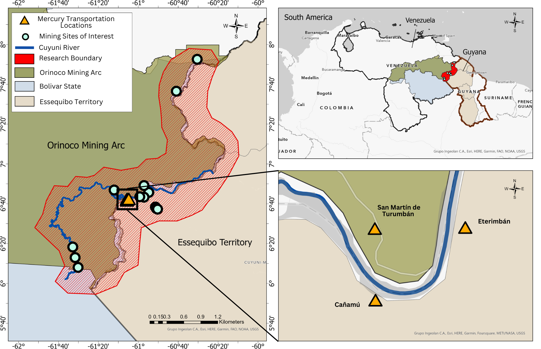
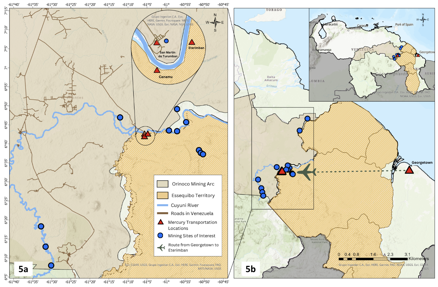
According to multiple sources (see aggregated source link), mercury transportation along the Venezuela-Guyana border has been prevalent between three settlements: San Martín de Turumbán in Venezuela and Cañamú and Eterimbán (also known as Etheringbang) in Guyana. The terms "Eterimbán" and "Etheringbang" are used interchangeably throughout this report. According to InfoAmazonia, "a network of journalists who investigate the main environmental issues in the nine countries of the Amazon", Cañamú is an informal settlement established in the Essequibo Territory, with the name made up by the locals.
On-the-Ground Reporting Linked to Placenames
A substantial basis of our analysis is linked to on-the-ground reporting from three credible sources: InfoAmazonia, Grey Dynamics, a London-based private intelligence company, and International Crisis Group, an international non-profit focused on conflict prevention. The quotes below with highlighted placenames (geolocated) set the tone for much of our further analysis and expanded imagery work:
While Mercury in Etheringbang is sold between 8-14 grams of gold per kilogram of mercury, in Ciudad Guayana miners are charged 25 grams per kilogram of impure mercury.
The economy of San Martín de Turumbán works like the neighboring Etheringbang. On the shore of the Cuyuní, there are dredges that dig into the earth in search of gold and carve out holes, as if a gigantic spoon had penetrated the riverbanks for several meters.
Guyana’s mercury has been cheaper in Eterimbán for a few months due to the opening of an air route to Georgetown.
You can buy mercury with no restrictions in any bodega in Eterimbán.
Guyana's mercury mainly pollutes the waters of the mines near San Martín de Turumbán.
From the town’s ramshackle boat dock you can see Cañamú, the hamlet where the miners usually buy the mercury used here.
The main currency in Etheringbang is gold. At the convenience stores, the prices are even denominated in it – 0.2g for a big jar of Nescafé, 0.3g for peanut butter. The town is far from any bank dispensing Guyanese dollars; the more readily available Venezuelan bolívar is nearly worthless, given the hyperinflation across the river.
According to a former senior ELN figure, the group has been active in the disputed border area between Venezuela and Guyana for about ten years. They control two river routes used for smuggling into Guyana from San Martín de Turumbán and five nearby mines.
Figure 1 below delineates the region of interest in this study with an emphasis on the three primary sites as potential mercury transport areas and the other mines under study. Due to the absence of regulatory oversight in Cañamú and Eterimbán, there exists an unregulated environment where mercury can be purchased or sold at local establishments.
Potential Gold Mining in the Study Area
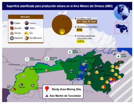
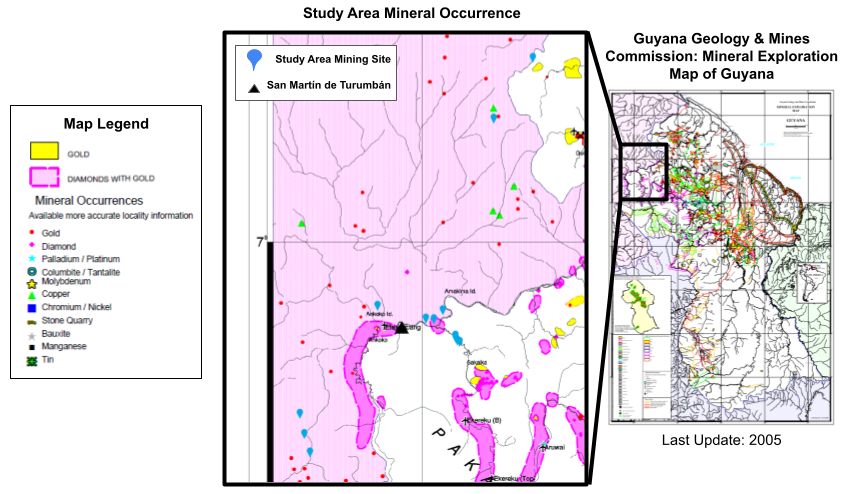
Figure 2 shows mineral areas in the Orinoco Mining Arc as identified by the Bolivarian Republic of Venezuela and depicts the planned surface for mining production in the Orinoco Mining Arc, with Area 4 marked as the area designated for gold mining with proximity to our study area geologically. For reference, "oro" is Spanish for gold. Figure 3 shows the presence of gold and gold mining sites within our study area, as identified by the Guyana Geology and Mines Commission.
Artisanal and small-scale gold mining (ASGM) involves the removal of aboveground biomass and the processing of alluvial soil sediments for the retrieval of minute historical deposits of gold particles. This type of artisanal alluvial mining has been historically practiced in the rivers south of the Orinoco by local and indigenous communities. Characteristics of this type of mining include small mining pits, small tailing ponds for mining site waste, trenches, and channels to access gold-bearing sediment, and discoloration of surrounding waters due to sediment runoff. Satellite imagery analysis can reveal these features. We have supplemented Figures 2-3 with suspected gold mining imagery signatures for all mining sites examined.
Possible Mercury Transportation Routes from Guyana
Air
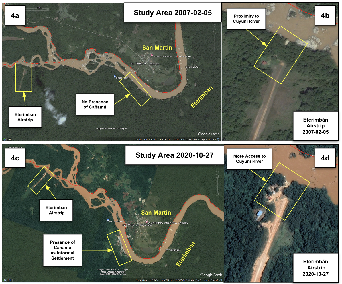
Figure 4 shows the "Eterimbán" airstrip near the study area from 2007 to 2020. Figure 4a-b shows the airstrip expanding with razed vegetation and light construction to the Cuyuní River. In Figure 4a, there is no indication of the informal settlement of Cañamú. According to InfoAmazonia reporting, ”there is no consensus on the founding date of Cañamú” and "what few call Cañamú, has grown between an unpaved airstrip and Etheringbang." According to OpenStreetMap, the airstrip near Etheringbang stands as the sole airstrip on the Guyanese side, opposite the "Aeródromo de Isla de Anacoco" in Venezuela, an airfield located approximately 2 kilometers to the north. In 2021, a news report from Guyana covered an aircraft crash that took place on the Eteringbang airstrip stating "mercury was aboard the aircraft."
River
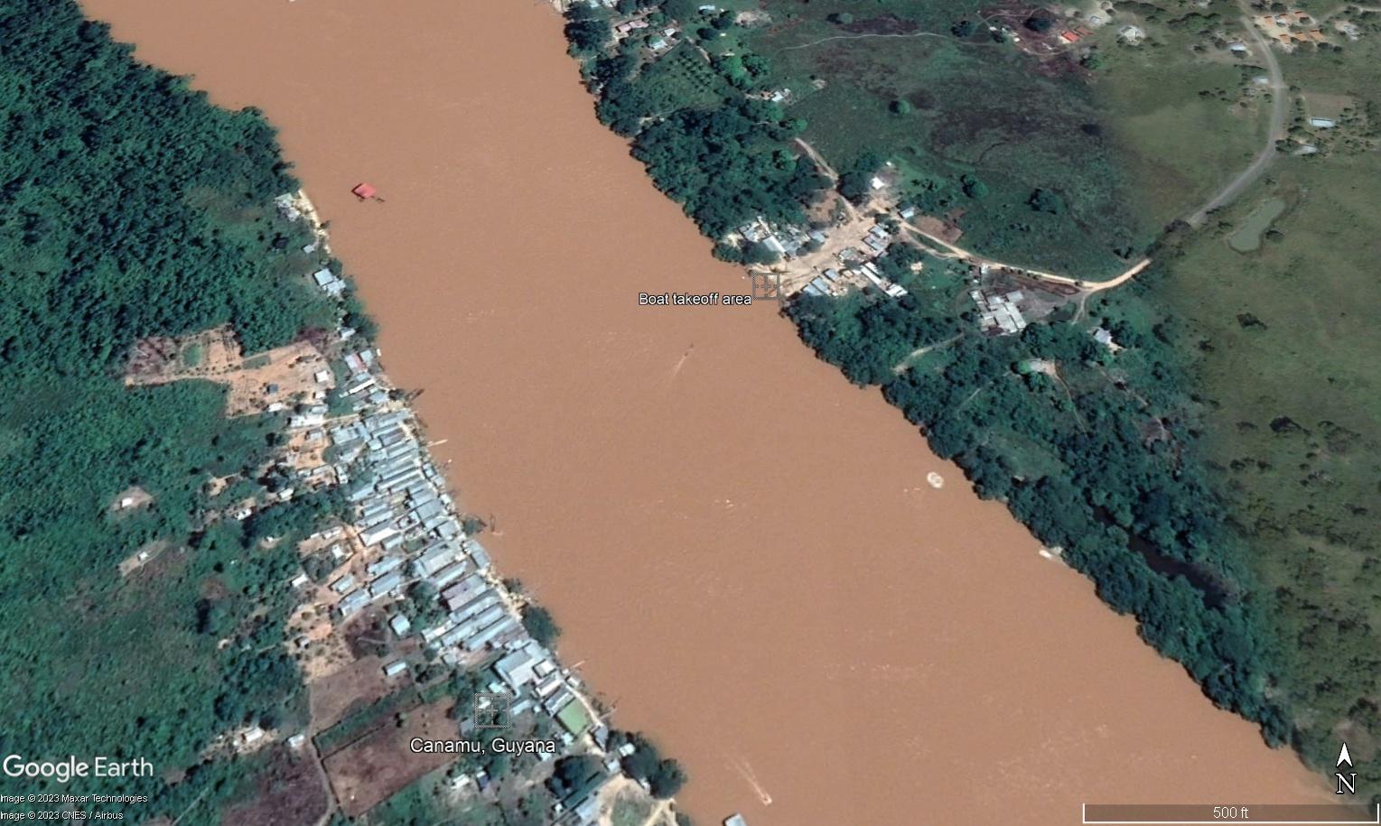
San Martín de Turumbán and Cañamú Imagery Analysis
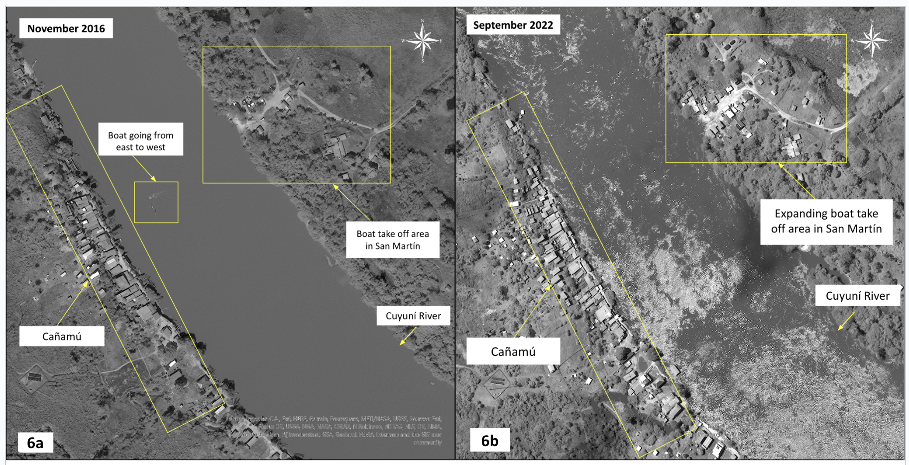
Figure 6 shows the regions of San Martín de Turumbán and Cañamú along the Cuyuní River. On the San Martín de Turumbán side, the boat take-off area witnessed significant expansion and the number of structures increased, suggesting a rise in activity over the observed period of 2016 (see Figure 6a) to 2022 (see Figure 6b). Similarly, the Cañamú territory has expanded, with structures suggesting increased activity as well. Moreover, in Figure 6a, a boat appears to be traveling from east to west, specifically from San Martín de Turumbán to Cañamú.
Roads
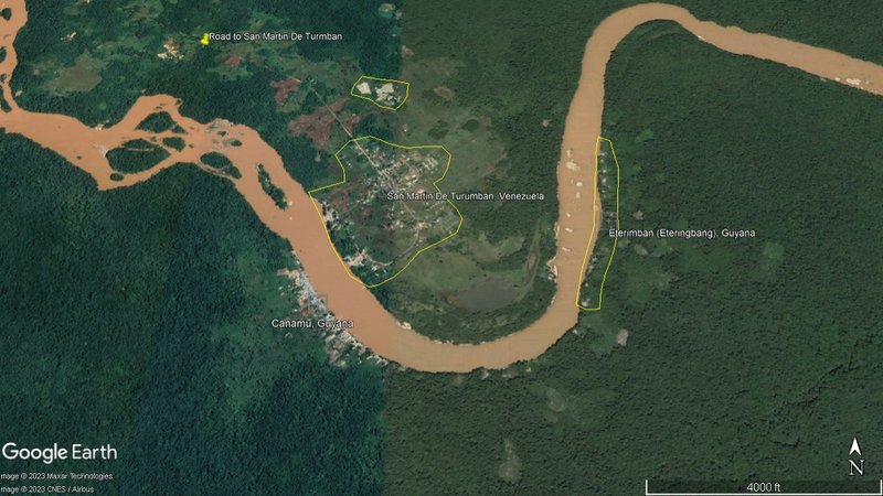
The Cuyuni River is a major transport artery, but it is not the only means of passage into the general area under study. Figure 7 notes the road leading into San Martín de Turumbán and also highlights the dense vegetation and remote nature of the Guyana locations under study where mercury can often be sourced on the cheap.
Expansion of Gold Mining in San Martín de Turumbán
Figure 8 represents the progressive expansion of gold mining activities in San Martín de Turumbán from 2017 to 2022. In Figure 8a, there is an initial indication of a gold mining operation above San Martín de Turumbán, featuring a mining pit and a mining tailing pond that have formed. This mining site expanded in Figures 8b and 8c with the addition of new mining pits and tailing ponds. Furthermore, in Figure 8a, there is a forested area on the outskirts of San Martín de Turumbán, directly across from Eterimbán, that has changed drastically over the years. Notable transformations transpired between Figures 8b and 8c as this area evolved into a landscape replete with mining pits and accompanying tailing ponds. Finally, Figure 8a shows a body of water located below San Martín de Turumbán and above the Cuyuní River. This water body underwent variations in coloration as the mining operations along the Cuyuní River escalated, as shown in Figures 8b and 8c.
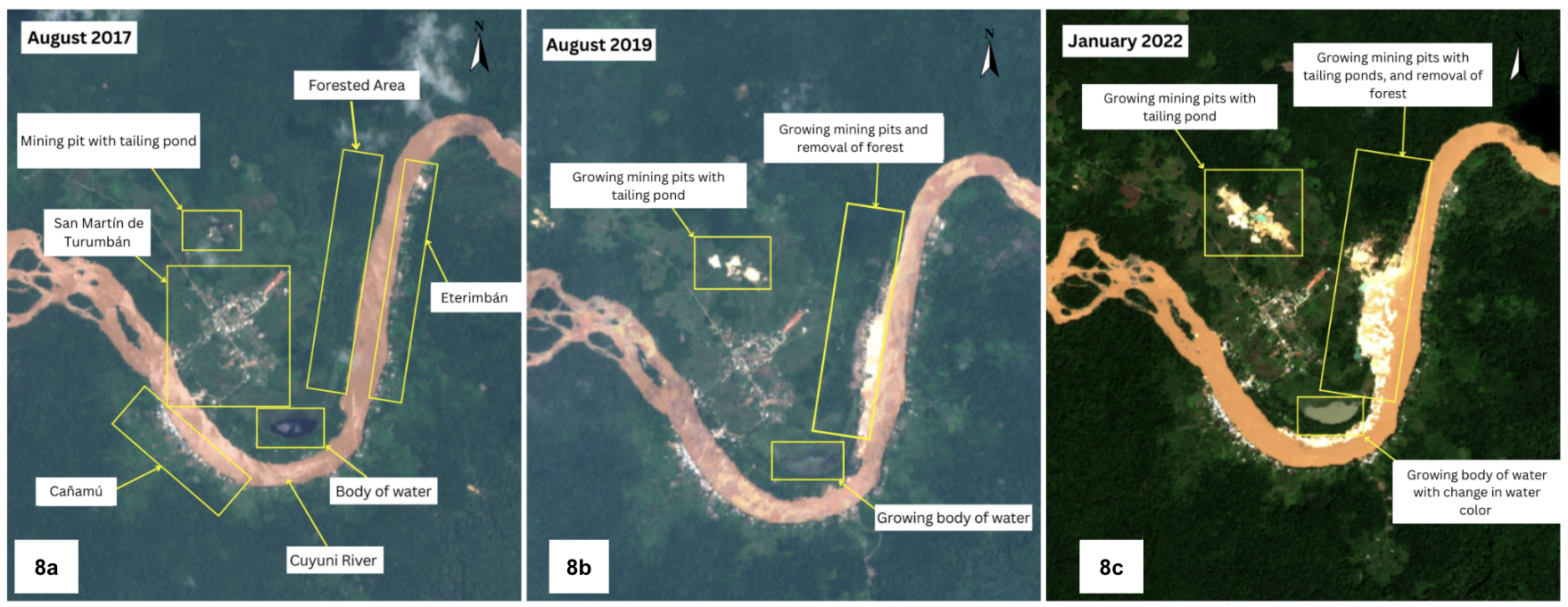
More recent commercial imagery from April 2023 reveals increased mining clusters along the river banks of San Martín as noted in the 2022 exemplar image in 8c. Additionally, there is an expansion of mining pit areas inland from the shoreline tailing ponds on the San Martín side as of April 2023.We described the most recent activity from the most current imagery in 2023 textually rather than releasing another snapshot as the exemplar imagery cited is sufficient to note the mining expansion trends.[1]
Comparative Analysis of Other Mining Sites in Venezuela and Guyana to San Martín de Turumbán
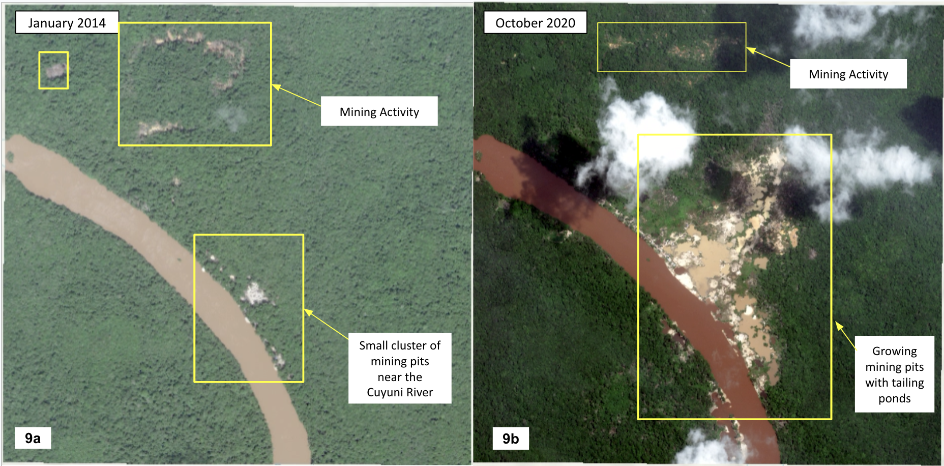
Figures 9 and 10 serve as comparison sites to the mining sites within San Martín based on a similar mining expansion and site characteristics over time. Figure 9a is located near the Venezuela-Guyana border on the Venezuelan side. This figure shows small clusters of dry mining pits near the river in 2014, and Figure 9b shows the increase in mining pits in the same area, in addition to tailing ponds, in 2020.
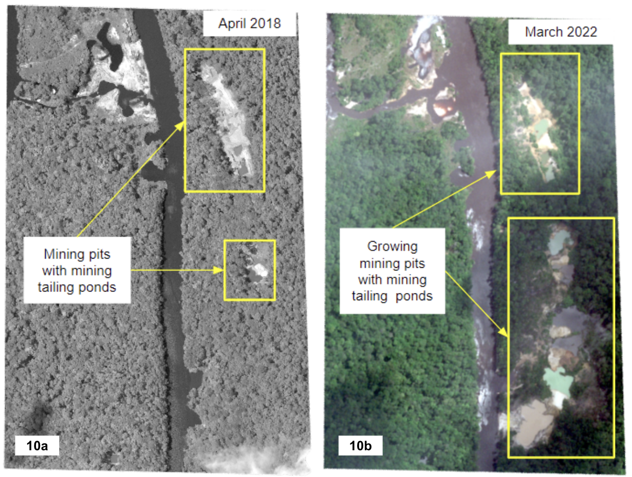
Figure 10a depicts a mining site located near the Venezuela-Guyana border on the Guyana side. This figure shows mining pits with tailing ponds near the river. Figure 10b demonstrates an increase in these mining areas in 2022. In parallel to the mining sites in San Martín de Turumbán, figures 9 and 10 show similar mining expansion over time. Similar mining signatures and proximity to the mines present in San Martín indicate that the mining activity in these nearby sites is probably also artisanal gold mining.
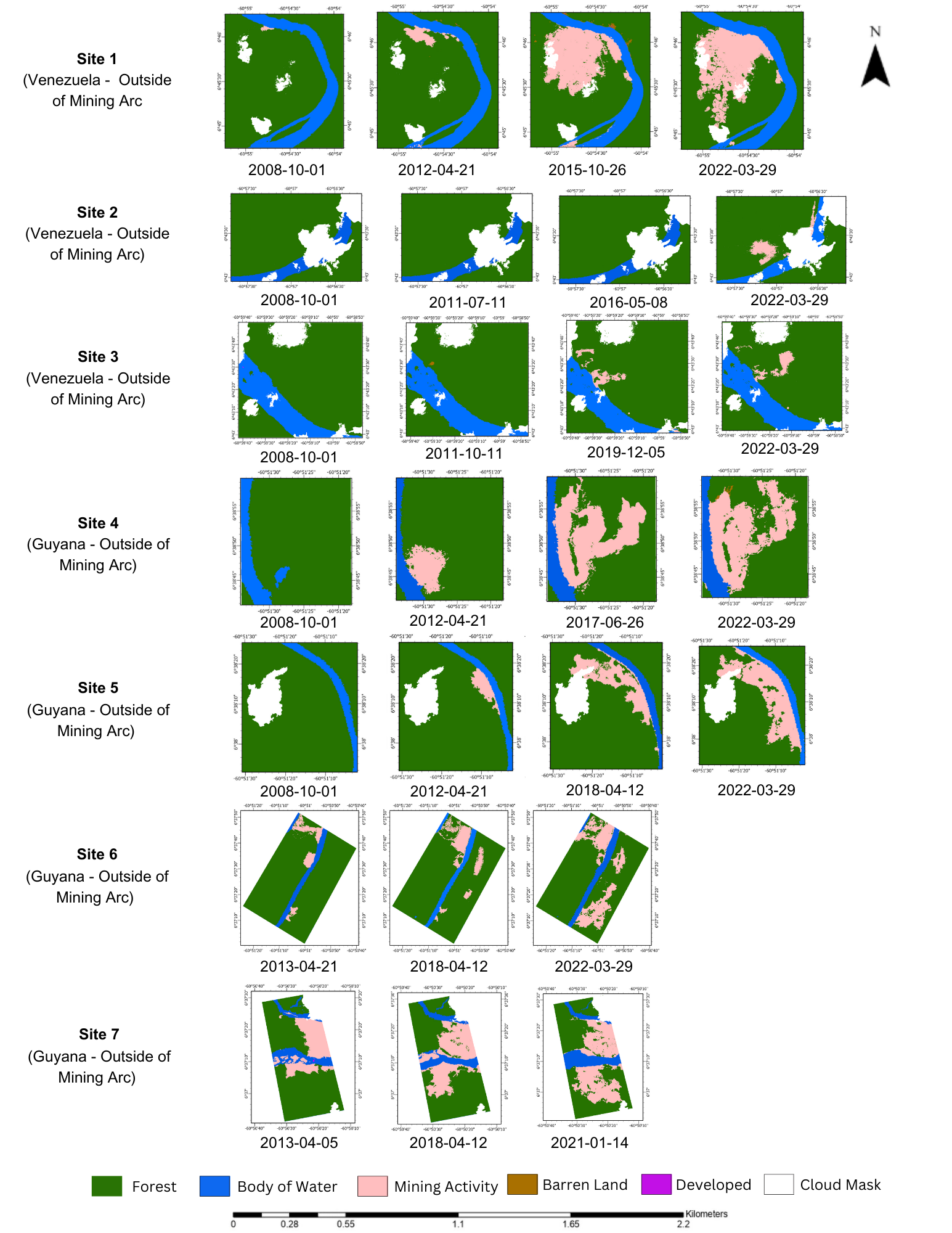
Land Use and Land Cover Change Analysis (LULC) of Gold Mining Sites Along the Venezuela-Guyana Border
We conducted a land use and land cover (LULC) change analysis to quantify the changes in land cover and examine the growth or contraction of mining activity.Mining 'contraction' typically does not occur without reclamation or environmental restorative efforts of the despoiled mining area. Imagery or land cover analysis of 'expansion' last noted in 2021 or 2022 is still assumed a despoiled area.[2] This automated mining detection was supplemented with literal imagery analysis of all 13 sites to ensure gold mining overhead imagery characteristics were present.
Methodology
The image classification utilized the 'Random Trees' algorithm in ArcGIS Pro. The land cover classes were: body of water, forest, mining activity, barren land, and developed. Post-classification processes included manual pixel editing and cloud masking to achieve accuracy assessments of above ninety percent over years of imagery coverage (depending on cloud cover and image availability). Area calculations and change analysis were carried out for the mining activity class to analyze the potential growth or contraction of mining activity at these gold mining sites.
Results
The total number of gold mining sites used for the LULC analysis was 13, with nine sites in Venezuela and four in Guyana. Figures 11 and 12 show the classified imagery generated in the LULC analysis scattered along the border of our study area. The class of interest is the mining activity class, which includes mining pits and mining tailing ponds. If barren land or developed land classes were inside mining activity areas, they were also classified as mining activity to represent the corresponding land use. Furthermore, clouds were masked out, resulting in the white spots in the images. The results in Figures 11 and 12 depict an increase in the mining activity class with a simultaneous decrease in forest over the time frame of 2008 to 2022. This common trend in mining activity expansion was present across all 13 mining sites sampled in the LULC analysis.
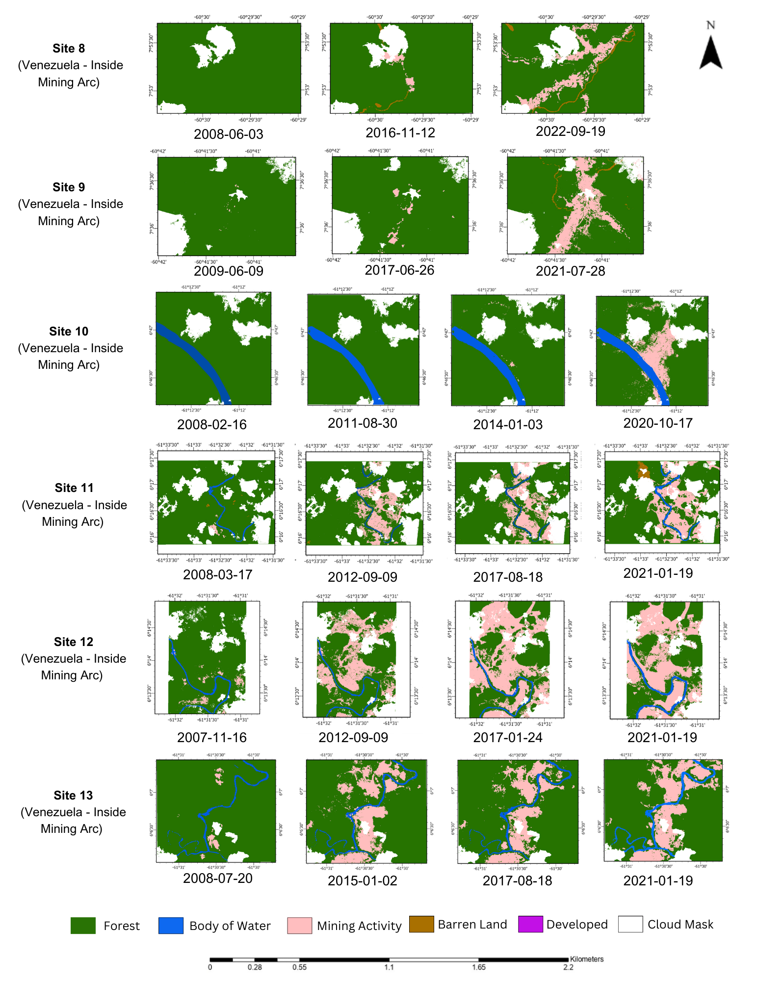
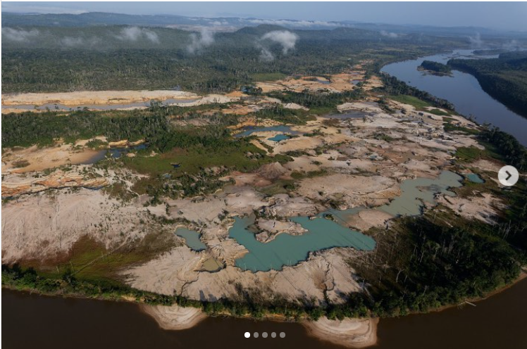
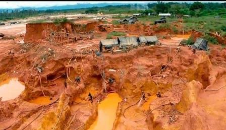
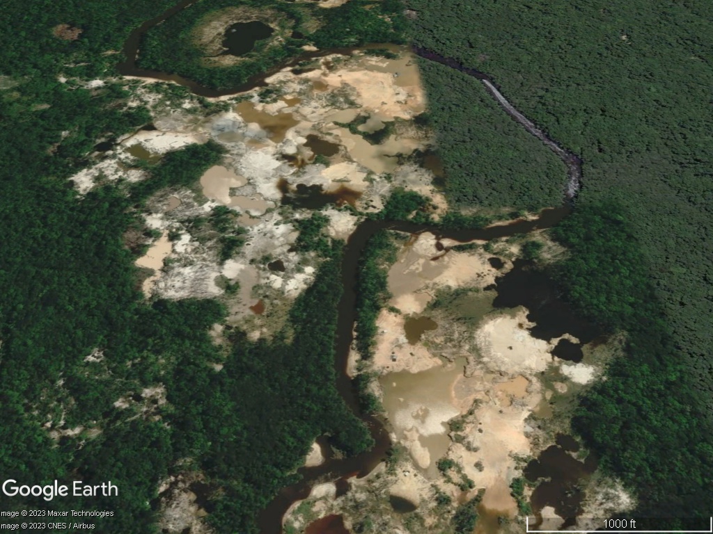
Characteristics of Gold Mining
To supplement the automated analysis, we analyzed all 13 sites from overhead imagery for characteristics of suspected gold mining. The general characteristics often include mangled and rough-looking brown or reddish soil scattered with spoon-like holes often filled with water or stand-alone holes and trenches. The water in the craters or ponds often changes color from greenish-blue to brown.
Venezuelan activist and journalist @valendeviaje's Instagram slideshow shows ground, aerial, and overhead photos of gold mining characteristics in Figure 13. She mentions the Cuyuni River in her post, which is part of our study area.
On June 2023, Mining.com reported that a gold mine collapsed from flooding in southern Venezuela, killing 12 miners. The mangled soil and spooned-out crater look are noted in the ground photo (Figure 14).
When ground photos are compared with overhead imagery, the characteristics remain consistent across different imaging platforms, as depicted in Figure 15. Please see the structured data flyovers for each site. The reader's imagery underlays may need to be updated to see all characteristics.
Graphs
Areas of Interest
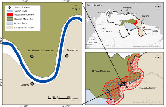
Venezuela-Guyana border: San Martín de Turumbán, Cañamú, and Eterimbán and other mining sites under study.
Source: Original Work, UMD students. Layers derived from Humanitarian Data Exchange
Look Ahead
Gold mining expansion along the Venezuela-Guyana border will further contribute to negative socio-environmental impacts within the region. Tracking gold mining expansion, mercury transportation, and the actions by both the Venezuelan and Guyanese governments in this region is necessary for monitoring Orinoco Mining Arc activity and the Essequibo Territory dispute. The next Tearline report will substantially expand the number of mining sites analyzed by automated methods with this report serving as a model training base.
Things to Watch
- Facing political and environmental pressure, will the governments of Guyana and Venezuela be forced to address the expansion of gold mining and the active roles of OAGs in mercury transportation?
- Will this study area become a larger hub for mercury transportation between Venezuela and Guyana?
- Will more unregulated and informal areas, such as Cañamú, develop along the Venezuela-Guyana border in the future?
- Expanded scope Tearline part 2 coming soon......


