
Overview
This is an article published by an NGA geodesy specialist on global navigation compatibility. This content is different than other Tearline content because the primary author is a government employee. Tearline is experimenting with this content type to broaden dissemination.
Activity
Compatibility testing was conducted of various Global Navigation Systems in 2019.
Collection and practical use of most modern geospatial data require that the data be represented in a well-understood global coordinate system. The National Geospatial-Intelligence Agency (NGA) has the mission to provide that global coordinate system and make it available for use in countless defense, intelligence, and civil applications. The scientific discipline where this happens is known as geodesy (aka geodetic science). The Global Positioning System (GPS), for example, operates in the NGA-developed World Geodetic System 1984 (WGS 84). This collection of models includes not only a global coordinate system but also a mathematical model of the Earth’s gravitational and magnetic fields, as well as other models that describe the small irregularities of the Earth’s motions as it rotates, wobbles, and travels in orbit around the sun. All real-time users of GPS, whether they know it or not, are using the NGA-established global coordinate system, known in modern terminology as the WGS 84 Terrestrial Reference Frame.
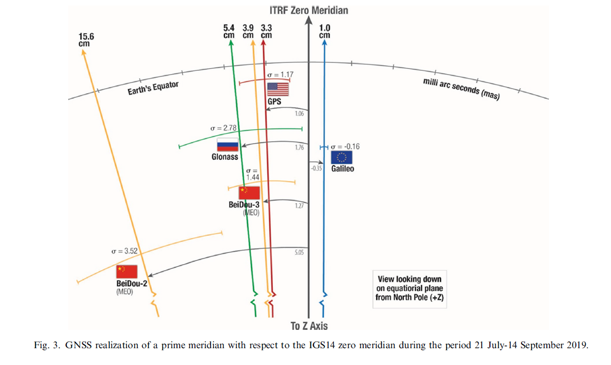
An important topic of interest to NGA is the level of agreement among the terrestrial reference frames used by GPS, the Russian GLONASS, the Chinese BeiDou, and the European Union’s Galileo. Each of these global navigation satellite systems (GNSSs) are operated independently of each other, yet commercial GNSS receivers all expect to use the broadcast radio signals from all of them in a combined so-called multi-GNSS receiver. This is why compatibility, or interoperability, among these systems, is an important issue. Together, for the foreseeable future, these GNSSs — through their respective terrestrial reference frames — now provide the foundational geospatial framework for planet Earth.
This is an important issue to sort out because location services affect services on your phone such as driving directions, restaurant location services, weather updates, geotagging your vacation pictures from your phone to social media, and many more.
The journal paper at the following link provides a rigorous assessment of the compatibility issue using data collected over an eight-week period in 2019.
Compatibility of Terrestrial Reference Frames used in GNSS broadcast messages
Look Ahead
Commercialization trends to watch:
Things to Watch
- more production of multi-GNSS receivers in phones
- more assisted positioning from phone companies
